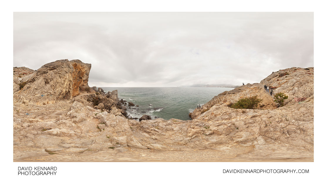
Southwest of Cape Alchak near Devil's Bridge

Description
- Title:
- Southwest of Cape Alchak near Devil's Bridge
- Caption / Description:
-
360° panorama from the trail around Alchak, near Sudak, Crimea. Cape Alchak (Мыс Алчак; Mis Alchak), also known as Mount Alchak (Гора Алчак; Goda Alchak) is a small mountain located to the south-east of Sudak. Its name comes from Crimean Tartar and means 'low', a suitable name with the mountain's peak being 152 metres above sea level.
Alchak is only 1 km in length and 600 m wide. In 1988 the area was declared as a nature reserve in order to preserve the valuable flora and geology of the mountain. A reasonably well kept path runs round the edge of the cape.
Fishing from the rocks of Alchak is a popular pastime, in this image several fishermen can be seen. Also visible is the Devil's Bridge (Чертов мостик; Chertov Mostik), a small wooden bridge that crosses a shallow but steep precipice. The name comes not from the current bridge, but rather the previous bridge, which consisted of an iron wire.
- Tags / Keywords:
-
- Europe
- Mountain
- Sea
- Ukraine
- Україна
- Autonomous Republic of Crimea
- Автономная Республика Крым
- Автономна Республіка Крим
- Qırım Muhtar Cumhuriyeti
- Cape Alchak
- Мыс Алчак
- Alchak Mountain
- Гора Алчак
- Cape
- Devil's Bridge
- Чертов мостик
- Kaznacheeva Mountain
- Казначеева гора
- Sudak municipality
- Судацька міськрада
- Судакский горсовет
- Sudaq şeer şurası
- Sudak
- Судак
- Sudaq
Admin
- Date Original Photo Taken:
- Original File Name:
- Pano SW Alchak nr. Devil's Bridge.psb
- Event:
- Rating:
- ☆
- Date this image added/last updated on website:
- Original File Dimensions:
- 15984px x 7992px
- File Type:
- JPEG
- Color Mode:
- Original Image Color Profile:
- Adobe RGB (1998)
Location
- Location Shown:
-
- Sublocation:
- Cape Alchak
- City:
- Sudak
- Province/State:
- Crimea
- Country:
- Ukraine
- World Region:
- Europe
- Location Created:
-
- Sublocation:
- Cape Alchak
- City:
- Sudak
- Province/State:
- Crimea
- Country:
- Ukraine
- World Region:
- Europe
- Geo-location:
- 44.831543333333, 34.9882 View on map
Rights
- Copyright Status:
- Copyrighted
- Licensing Status:
- Rights Managed
- Available for Editorial Use:
- Yes
- Available for Commercial Use:
- Yes
- Copyright Notice:
- © 2013 Dave Kennard
Camera Data
- Date Digital Resource was created:
- Shutter speed:
- 1⁄160 s
- Aperture:
- f/11
- Camera Model:
- Canon EOS 5D Mark II
- ISO:
- 100
- Exposure Compensation:
- 0
- Focal Length:
- 17mm
- Focal Length (35mm equiv.):
- Metering Mode:
- Center-weighted average
- Flash:
- Off, Did not fire
- Exposure Mode:
- Manual
- White Balance:
- Manual
- Light Source:
- Exposure Program:
- Manual
Additional shooting metadata
- Lens:
- Tokina ATX107 DX FishEye 10-17mm F3.5-4.5
- Filters used:
- Additional Optics used:
- Setup:
- Benro C-428 Tripod
Nodal Ninja 3 II Rotator and lower rail
Nodal Ninja 3 vertical arm and upper rail
Arca Swiss Compatible Quick Release Clamp
Remote shutter release
6 shots around, 1 up, 1 down, 1 down handheld, all bracketed ±1.3EV
Post Processing
- Image Modified:
- Software used:
-
- Adobe Camera RAW
- Adobe Photoshop CS5
- PTGUI 9 Pro
- Post Processing:
RAWs converted in ACR
Images stitched and blended in PTGUI 9 Pro
Images blended for exposure in PS CS5
